About Us
GAVIN is a strategic technology company from Indonesia, a pioneer in deep tech enablement and a leading system integrator in the country. The company has developed an AI-powered Digital Twin. For over a decade, GAVIN has been innovating and collaborating with various cutting-edge technology vendors to deliver advanced solutions that address complex challenges in sustainable regional planning, management, and development. We bridge world-class technology with Indonesia’s unique needs
Product and Services
GeoInformatics and Automation Solution Provider
Smart City & Urban Technology
Geospatial AI & Data Intelligence
Digital Twin Platform & IoT Integration
Environmental, Infrastructure & ESG Analytics
GeoAI Satellite Imaging & Simulation
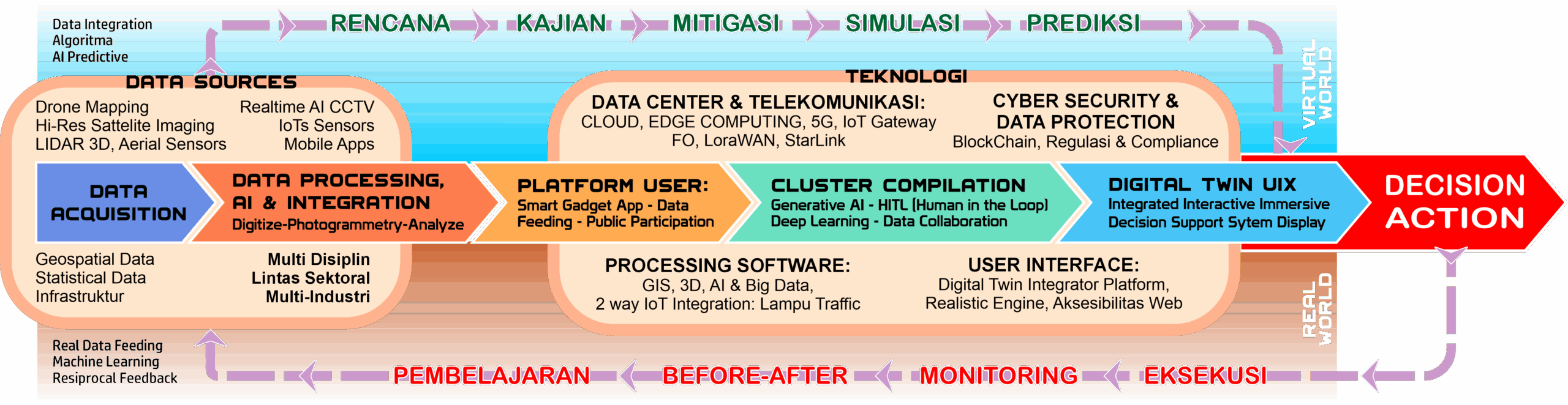
From Data to Intelligent Decision & Action
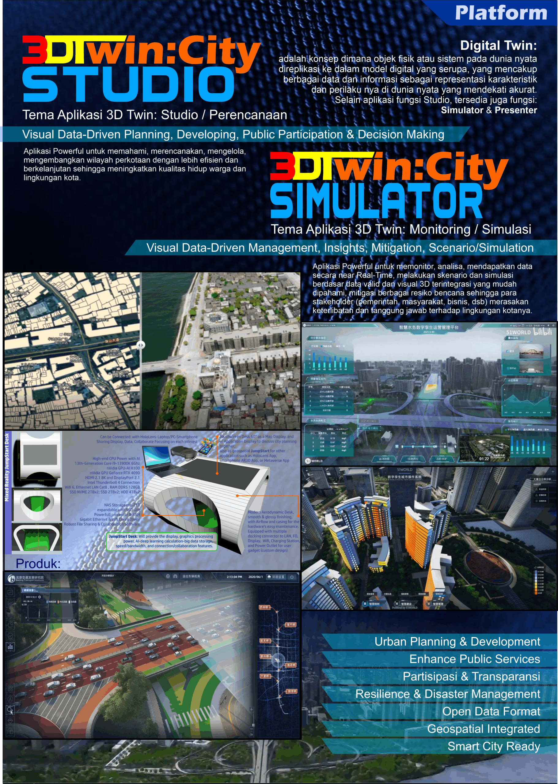
"An integrated, real-time Digital Twin platform. Imagine your city, district, or assets in the form of an interactive 3D model that comes to life, enriched with accurate data and intelligent analytics for better decision-making."
- High-Resolution & Near Real-Time Data Acquisition (Drone Mapping, LiDAR, AI-based Satellite Remote Sensing, IoT Sensors)
- AI Analytics & Data Processing (classification, prediction, simulation, 3D modeling) tailored as custom applications for specific regions and related industries: manufacturing, tourism, cargo, seaport/airport, automation, and more.
- Immersive 3D UIX Command Center & Dashboard Systems: Spatial Planning (RDTR), transportation, agriculture, mining, renewable energy, environmental management, 3D AR/VR games, 3D movies, cultural heritage object preservation, and mor
- Digital Twin Data Platform and Integrator: Digital replication/mirroring of real-world objects, characteristics, and physical conditions, enhanced with AI for increased accuracy. Accessible via Cloud-Based Software as a Service, Data as a Service, or local on-premise systems.
- Hangar Services: Procurement, maintenance, storage, and operational readiness of data acquisition equipment (drones, sensors, AI servers), ensuring availability at any time to prevent functional deficiencies — including consulting, master planning, technical guidance, and certification.
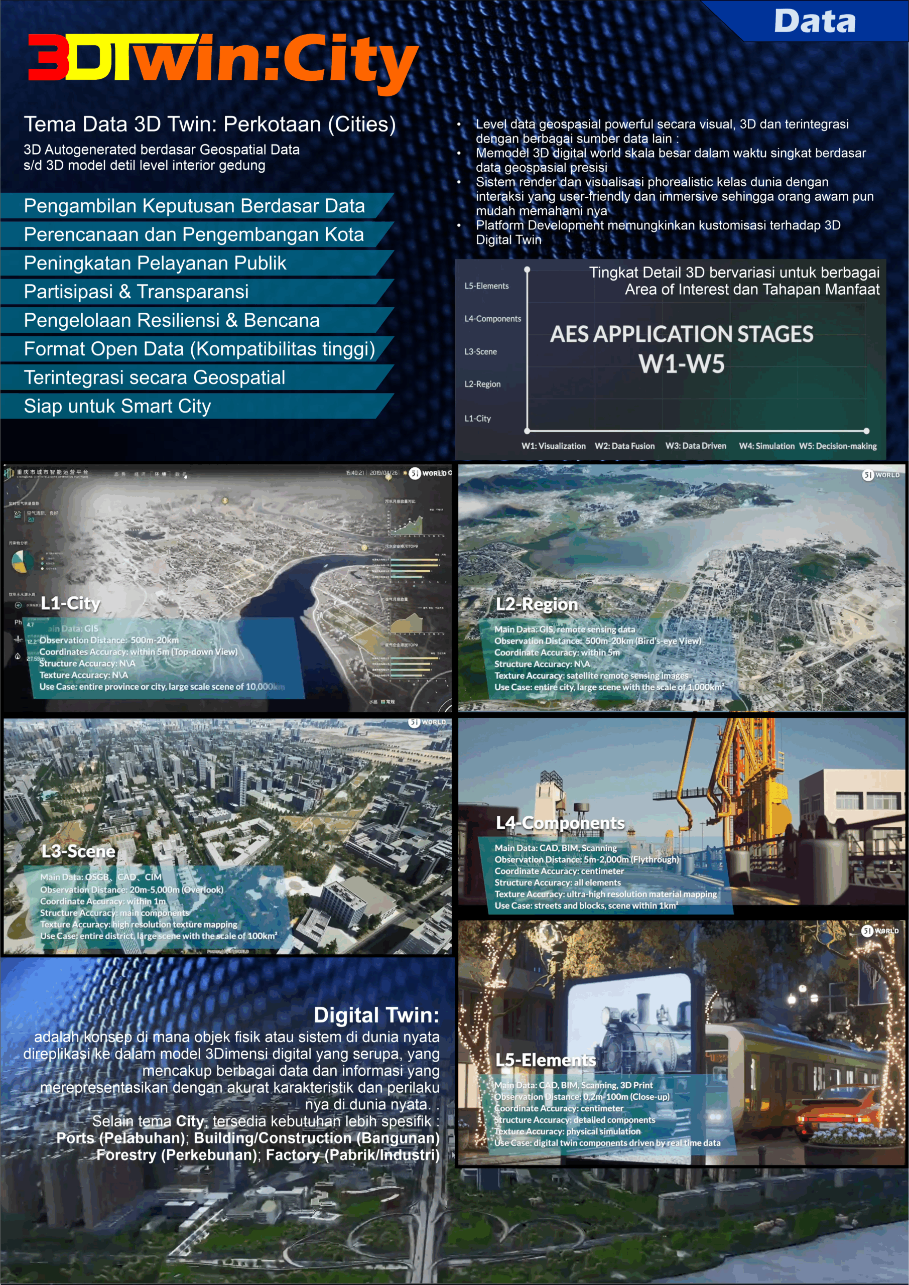
Utilization of Digital Twin Technology
Digital Twin, as a digital representation of a city, is not a static system where everything is completed in a single project. Instead, it is a long-term platform that continues to evolve and adapt to the city's dynamics over time. It constantly learns and refines its algorithms based on regularly updated data. As a result, the city replica becomes increasingly precise, enabling more accurate policy simulations and planning.
Feature and Dashboard
Benefit
Key Benefits of Partnering with Gavin
Planning, Monitoring, and Simulation More Accurate & Efficient: Save time, costs, human risks, environmental impact, and other disaster mitigation efforts through precision data-based simulation and analysis."
"Faster, More Accurate & Scientific Decision-Making: Gain real-time insights to respond to on-the-ground dynamics."
Enhanced Transparency & Accountability, Improved Public Service Quality & Competitiveness: Easy-to-understand data visualizations support good governance.
Collaboration Between Parties Becomes Easier: An integrated platform facilitates coordination between institutions/divisions and the public, encouraging public participation, a sense of ownership, and collaborative development.
why Choose us
#1 Integrated Smart Digital Twin City in Indonesia
Pioneer & Grand Designer Studio Jakarta Satu: The first urban spatial planning digital twin and benchmark in Southeast Asia, within the Studio Jakarta Satu platform.
(Aerial Mapping + GeoInformatic Solution + UAV Solution)
why Choose us
1st UAV Flight over Urban Area Jakarta
- The first officially licensed and certified company in Indonesia to operate drones in Jakarta's urban area.
- A pioneer in the integration of aerial mapping technology, geospatial data (RDTR, land parcels, and investment potential) at the Jakarta Investment Center
- Trusted by Various Sectors: Bappenda, the Environmental Agency, leading property developers, and prominent players in the plantation, forestry, and agriculture industries.
- Global Partnerships & Recognition: Strategic partners 51World (China) and Star.Vision (Singapore-China), along with recognition from academics (EuroUnion #2 champion for Green Circular Entrepreneurship) and various other multidisciplinary fields, as well as media and international forums.
- Integration of Various Geospatial Data Sources, Statistics, Spatial Planning, Investment Potential, and Development, with 3D AR/VR for Future Location Planning and Potential Development.

What Our clients and partners say About Us
SILMI R
Tenaga Ahli Pusdatin DCKTRP
Ema Kharisma
Analisis Sistem dan Integrasi Data Geospasial Pusdatin DCKTRP
Dr. Phil., Ir., ST, MAUD, MURP, IPU, ASEAN Eng.
ITI
Ema Kharisma
Analisis Sistem dan Integrasi Data Geospasial Pusdatin DCKTRP
Partners
Client